Sunday, December 31, 2017

The Strong Great Lakes Mesovortex of 30 - 31 December 2017

One of the strongest lake-induced mesoscale vortices I've seen struck Marquette, MI yesterday with 60 mph wind gusts and an amazing longevity as it survived a passage over the UP of Michigan and then dropping straight south down the long axis of Lake Michigan last night to eventually make final landfall midday today on the Michigan, Indiana shoreline. The Great Lakes produces numerous vortices during its convective lake effect season, ranging from small misocyclones less than 4 km wide documented by a study by Steiger and co-authors in 2013, to 4-50 km mesoscale vortices documented by Laird and co-authors in 2001. Some misocyclones have been reported to have caused winds strong enough to break tree limbs along the Great Lakes shorelines possibly as they've intensified into weak tornadoes. But I have not heard of the larger vortices being strong enough to do the same kind of damage.  

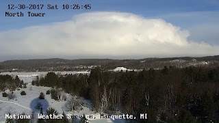
These vortices can produce impacts when well-behaved snow bands suddenly take sideways departures to visit areas not predicted to receive snowfall. This one produced impacts even in an area well-accustomed to lake effect snow. The snowfall rate and high winds shut down at least one state highway where an accident shut down US-41 south of Marquette. An employee at the NWS Marquette shot two pictures of the event, one of the main convective band associated with the mesoscale vortex approaching them and then a few minutes later, a whiteout.


A tweet showing US-41 shut down due to whiteout conditions and an accident.

A picture, taken from the NWS Marquette, MI, shows the main convective band approaching shore to the north.


The peak wind gusts reported reached 60 mph near Marquette as the convective band on the western flank of the mesoscale vortex passed over the station.  The surface map provided by NWS Weather and Hazards Viewer.


As the mesovortex passed to the south and into Lake Michigan, residents around the Grand Traverse Bay tweeted pictures of funnel clouds, certainly representing tornado-like vortices. I'm not sure where these waterspouts were located relative to the mesolow but they may have been within a few hours of its passage.  It goes without saying that the mesolow was ripe with vorticity and the available convection to help concentrate into misocyclones and perhaps even weak tornadoes.


https://twitter.com/NWSGaylord/status/947266131450105861/photo/1

The impacts continued down Lake Michigan although perhaps in an unexpected way. The lake effect band plaguing the south shore of Lake Michigan for some hours quickly weakened before the arrival of the mesovortex, potentially providing a narrow window of unimpeded travel. However the arrival of the mesolow meant that snowbands reoriented themselves and reached areas not expected to experience lake effect given prevailing synoptic scale wind direction. The east-west band slapped a broad section of the southern lake Michigan shoreline with rapidly dropping visibilities and enhanced winds capable of causing brief whiteouts. While the shoreline didn't see the 60 mph winds from yesterday's Lake Superior landfall, they were certainly strong enough to simulate the wintertime equivalent of a thunderstorm but with the extra benefit of whiteout conditions and added ice cover on road surfaces.


A video loop of the Northern Indiana WSR-88D showing the impact of the mesolow on the location and behavior of the snow bands.


Maximum wind gusts from today's mesolow landfall in southern Lake Michigan.  Image courtesy of the Weather and Impacts display from the NWS.


This mesovortex event provided a platform to showcase two amazing advancements in meteorology. The first is the major upgrade in our GOES. The recent launch of GOES-16, and its placement as the eastern operational satellite provided a spectacular rapid update loops of the development and intensification of the mesolow over Lake Superior. the last minute explosion of convection that the canvassed the northern view from the NWS MQT office was well-captured one one-minute intervals from the satellite, manifested as rapidly expanding and glaciating anvils, similar to a summer thunderstorm. The satellite captured smooth ribbons of lake effect cloud streets converging into the mesolow from the north and east. The Marquette WSR-88D complimented the satellite by showing the internal structure of the mesolow and the strong winds whipping around its western flank.


The next day the new GOES captured another convective explosion just offshore of Lake Michigan's southern shore. The satellite explicitly showed the new convection convert from bright liquid water clouds to mostly ice the same way it did for summer thunderstorms.


The second showcase was the eerily accurate prediction by the NAM, NAM 3km and the HRRR models from even two days in advance. This amazing success was partly courtesy of the excellent analysis of the low pressure in advance of the arctic front over Lake Superior from the day before it intensified. But the models could take advantage of the excellent lake temperature and ice cover analysis, as well as the model advancements that allowed them to accurately depict the structure and motion of the mesolow.


NAM 3 km surface temperature and wind analysis from the night before the mesolow formed and intensified before hitting Marquette.

As an example, the 3 km NAM from the previous night accurately depicted the strong winds on the mesolow's western flank approaching Marquette during the middle of the day. It may have fallen short of the peak observed wind speeds but it certainly was good enough to show that a sudden onset whiteout conditions could be possible. And then in even more spectacular fashion, the same model run moved the mesolow down the axis of Lake Michigan.   


NAM 3 km 16 hour forecast surface winds and sea level pressure from 00 UTC Dec 30.


This persistent scenario depicted by the models prompted at least one NWS office to draft up a forecast and publish headlines announcing the mesolow's arrival a day ahead.


Finally, this mesolow has many of the characteristics of a tropical cyclone and polar lows.  It intensified over relatively warm waters of Lake Superior while a deep convective layer allowed for more intense concentration of the loose low pressure into something much tighter than I've seen before.  A deep convective layer for this time and place is only about 3 km.  The center of the low was surrounded by warm air, of 19-20 deg F, not the single digits or below zero readings from inland.  Perhaps the strong warming was partly courtesy of strong sensible heat fluxes when the mesolow began to intensify. It's a feedback process that can help explain the genesis of tropical cyclones.  In this cold environment, the process can only go so far.  Yet we're not talking about a cat 5 potential environment, just one strong enough to do what we've seen here.

A model sounding over Lake Michigan near the mesolow depicting the 3 km convective layer and vigorous vertical motion (horizontal orange lines).  Image courtesy of COD and SHARPPY.


Laird, N. F.L. J. Miller, and D. A. R. Kristovich2001Synthetic dual-Doppler analysis of a winter mesoscale vortexMon. Wea. Rev.129312331, doi:https://doi.org/10.1175/1520-0493(2001)129<0312:SDDAOA>2.0.CO;2.  Link

Laird, N.F., L.J. Miller, and D.A. Kristovich2001Synthetic Dual-Doppler Analysis of a Winter Mesoscale Vortex. Mon. Wea. Rev., 129312–331,https://doi.org/10.1175/1520-0493(2001)129<0312:SDDAOA>2.0.CO;2 

Linders, T. and Ø. Saetra2010Can CAPE Maintain Polar Lows?. J. Atmos. Sci., 672559–2571, https://doi.org/10.1175/2010JAS3131.1 

Steiger, S.M., R. Schrom, A. Stamm, D. Ruth, K. Jaszka, T. Kress, B. Rathbun, J. Frame, J. Wurman, and K. Kosiba2013Circulations, Bounded Weak Echo Regions, and Horizontal Vortices Observed within Long-Lake-Axis-Parallel–Lake-Effect Storms by the Doppler on Wheels. Mon. Wea. Rev., 1412821–2840,https://doi.org/10.1175/MWR-D-12-00226.1 

Sunday, January 22, 2017

Rare and dangerous high risk of tornadoes in GA and FL


I haven't seen tornado outbreak environments like this in some years.  The latest Storm Prediction Center (SPC) outlook still has a high risk for severe storms including long-track significant tornadoes for portions of south Georgia into north Florida.  The last time that a high risk was issued by the SPC was almost three years ago according to Skip Talbot's Facebook post, and possibly no high risks have been forecast into the Florida peninsula.  Now storms are starting to form along and ahead of a cold front in the western FL panhandle and north along the GA, AL border.  Newer storms are firing up along the cold front south into the Gulf.  These should be of interest to anyone concerned about their safety which should include especially the high risk zone.

Later, more isolated storms will fire to the south and threaten the Florida peninsula.  While they may be more isolated, the environment will also support the potential for strong tornadoes.  The risk may not be high for Tampa, Orlando and Melbourne, but if you're unlucky enough to be in the path of a potentially tornadic storm, assume it'll produce significant tornadoes putting you at risk.


Areas north of the high risk may not see an obvious environment supportive of tornadoes because of the widespread rain in southern Georgia.  However this system is unusually far to the south, and our collective experience, limited.  Thus I suspect that even western to central Georgia may see a tornadic threat as the surface low deepens dramatically to something rarely seen in central GA - up to five standard deviations below normal for this time of year.  Outside of hurricanes, the sea level pressures will be very low down into FL as well.  As a result low-level winds will be strong and that means that if you're experiencing a cloudy, cool rainy atmosphere now, that may change quickly to one favorable for severe weather very quickly.   Residents in the Huntsville, AL area on the super tornado outbreak day of 2011 can relate to that.  Temperatures were in the 50's all afternoon and then in the last hour, jumped to near 70 deg F quickly followed by a mile-wide long-tracked tornado.


Furthermore, the probability that any one supercell will produce a significant tornado currently stands in the 15% range according to research by Smith and Thompson and Marsh of SPC in the last few years.  Get used to those numbers being extremely high.  As cases are gathered and return intervals calculated, you may see them as rather unusually high.  More importantly is that these numbers will go up from here as the day progresses.  The key thing to consider is that area hodographs feature large storm-relative helicity, very humid atmosphere (in an absolute and relative sense) and lots of buoyancy for thunderstorms to grow uninhibited, as seen from this sounding from the HRRR in the FL Panhandle ahead of the storms.


Bottom line, if your sheltering location is dusty, or cluttered, clear it now!


Thursday, January 12, 2017

What will roads be like Friday-Saturday central OK?

The next winter storm is upon us one week after the cold snow we experienced.  This time it's ice that's in the forecast and one big question is what the roads will be like.  After a nearly record warm day on Wednesday with temperatures near 80 deg F, the ground temperatures are at least 10 deg F warmer than right before the snow storm and with temperatures expected to drop to just a couple degrees below freezing, it'll be tough to cool the ground surface to below freezing.
But we're talking about freezing rain, right?  It makes all the difference in the world and this time the trend will be to keep ground temperatures warm.  As opposed to already frozen precipitation where upon landing and melting, extracts heat from the ground, rain deposits energy into the ground upon freezing.  If the ground, or the road surface, were to freeze, the energy will have to be extracted by another mechanism.  A continually fresh and deepening source of arctic air could accomplish this task.  However forecasts from all numerical guidance and the NWS paint a scenario where the near surface air barely remains below the melting point throughout Friday and into Saturday morning, early.  This is hardly the needed reservoir of cold required to cool the ground below the melting point in the face of all the latent heat to be added as the rain attempts to freeze.


Consider also that the rain will be falling from a layer nearly at 60 deg F a few thousand feet above ground and you are asking a lot of barely subfreezing air to cool the rain drops while also extracting heat from the ground and successfully fighting off the latent heat added by any attempts at freezing.


All this points to road surfaces remaining wet in central OK throughout the duration of the freezing rain event.

Now the exposure of elevated roads paint a different story.  The reservoir of heat will be eroded from multiple sides, allowing the surface to potentially reach a little below the melting point and allowing the potential for falling rain to freeze.  Bridges and overpasses could become slick if untreated.  But this event is well-forecast and hopefully the OKDOT attacks elevated surfaces before precipitation starts.  Since the NWS forecasts the potential for hazards to occur, they can't depend on knowing for sure what our efforts of mitigation may entail and thus pay heed to these graphics below.

The bottom line is that elevated surfaces may become slick, if untreated in central OK while colder air could be sufficient for all untreated roads in NW OK.

Ice will accumulate on all trees, power lines in central and NW OK.  However NW OK is most likely to bear the brunt of the heaviest rainfall.     Three quarter to one inch accumulation of ice will cause power outages there, and into Kansas and adjacent Missouri.  While this storm will not likely be equivalent to the catastrophic ice events of the past 16 years, it'll be bad enough.


Thursday, January 5, 2017

Fast moving snow system to hit central OK tonight

Our first accumulating snow event of the season is looking more likely tonight.  I've been monitoring the forecasts over the past several days and only by two days ago did the forecasts have enough confidence that snow would indeed happen.  The impacts will be quite clear.  Confidence is high that a period of accumulating snow will occur between midnight and 6 am, with the heaviest rates occurring within a couple hours of 3 am.  The timing and accumulations are pretty well represented by the 09 UTC short range ensemble forecast (SREF) of snow depth, to which the NWS forecast office agrees.  However, the SREF forecasts a large uncertainty in snow fall, anywhere from 0.5 to 6"!  If you're the cautious type, you may want to consider planning for a 4+ inch event with much of it coming down in a hurry just before the morning rush hour begins tomorrow.


But you may want to ask how much of that snow will stick to the roads.  Considering the possibility that no road crews go out tonight to pre-treat the roads with salt, an apt possibility for neighborhoods and minor roads, then all of the falling snow will remain frozen after landing.  We've had nearly 36 continuous hours of subfreezing air, broken only by a few hours of temperatures a little above freezing yesterday afternoon.  The Oklahoma mesonet soil temperatures 2-5 cm below ground in east OKC responded to yesterday's warm temperatures by rising to 40 deg F but since have fallen below 35 deg F this morning.  Other central OK mesonet soil temperature sites have responded similarly.  With plenty of arctic air feeding in from the north, all forecast 2 meter temperatures remain well below freezing, with a falling trend, through tonight and into tomorrow morning.  The ground temperatures should easily fall below freezing before the first snow falls.  Certainly all elevated roads will be even colder.


The impact means all untreated roads will be snow covered by 5 am tomorrow.  These include neighborhood roads and minor streets, or in other words, where most people will attempt to depart.  On the other hand, I would expect main snow routes, highways and bridges to be treated in advance of the snow.  Once they're treated the chemicals should easily melt a 2" snow cover within a couple hours of the snow ending which should be in time for the majority of a morning commute as a majority of forecast guidance anticipates snow tapering off by 6 am.  I would expect an hour or two delay should be sufficient to allow any remaining snow on treated routes to melt.

Now to be cautious, there are a few possibilities that may cause further delays for you.  The temperatures tomorrow will remain well below freezing and so all unplowed snow in shaded roads will remain and there's a good chance enough clouds will remain that even normally sunny road surfaces will stay below freezing.  Another issue could be if the DOT is delayed treating roads until the morning.  You'll know quickly about that if you come upon a normally treated road and it's white.  Or there is a third possibility of snow covered roads, even in treated areas, if the snow fall exceeds forecasts or if the heaviest falling snow gets delayed into the morning commute.

What is the possibility of getting more snow or the heaviest snow occurring after 6 am?  I expect the possibility of both to be there.  To understand why, consider the plots below.  Our event will come from the intersection of an upper level storm system, marked by the 'L' in northern California this morning, and the elevated frontal boundary marking the top of the arctic air dome shown by the strong temperature gradient at the 700 mb level seen below.  This type of upper-level storm provides forcing for rising motion well above the ground usually in the shape of a wave  and the front provides the assist a little lower in the form of bands parallel to the temperature contours.  The relative humidity pattern at the level of the frontal boundary aloft, also at 700 mb, indicates the air is already saturated and likely lifting along bands.   When the upper-level system begins to arrive late tonight one or more bands along the front may intensify and drop heavy snow, heavier than forecast.  The higher resolution models show some indications of bands, however the southern one doesn't last long appears to be more a reflection of the upper-level system.  Yet a stationary band across the metro area is in a realm of possibilties and it could last into the morning commute resulting in plowable snow accumulations and more snow covered main routes.


One final interesting thing to consider with this snow event is whether or not we'll get the beautiful six-sided dendrite crystals.  Consider that to get this kind of snow, we want to see strong rising motion occurring in the -12 to -18 deg C temperature layer aloft.  Consider a forecast sounding below from the morning NAM model.  The cold air at low levels is forecast to become cold enough to generate dendrites but there's not much in the way of rising motion.  However thanks to warm air above the arctic air layer, we extend the optimal temperatures for dendrites into the layer where strong rising motion is forecast to occur.  So with the cold surface temperatures, we should wake up to lots of dendrites.  That's in theory.  In reality, lots of factors may interrupt the processes to create spectacular dendrites but at least the possibility is there.