Our drought seemed to have caught me unprepared for this evening where the clouds actually consisted of liquid water and a sun pillar formed. A field of altocumulus clouds spread overhead from the west marking creating another spectacular sunset, one that I hopefully adequately captured from the bottom of Lake Thunderbird's Jim Blue bay.
 |
| An altocumulus-filled sunset from Lake Thunderbird 2013-02-11 2354 UTC. |
This cloud layer occasionally sported small trails of snow precipitating out from each individual altocumulus. The altocumulus clouds were cold, but how cold? To answer this question, I referred to a vertical sounding taken at the National Weather Center. The balloon usually launches around 23 to 23:15 UTC, or up to 50 minutes before this shot was taken. The altocumulus clouds were overhead at launch time and so I'm pretty confident that the thin layer of moisture at 600 mb in the sounding below represented the altocumulus layer. If so then they were centered around -10 to -15 deg C, right about the temperature where snow crystals like to form fairly quickly.
 |
| The vertical sounding taken at Norman where the balloon likely passed through the altocumulus layer at about 2330 UTC. |
A little later, a spectacular sun pillar formed to our west as the sun fell just below the horizon. Unfortunately I was caught off guard eating dinner after shooting the early pictures, and so my only picture was taken through a nest of Post oak branches. Other folks in town were more
fortunate and grabbed some really nice unobstructed shots.
 |
| A sun pillar caught through the branches of our trees at home taken 2013-02-12 0018 UTC. |
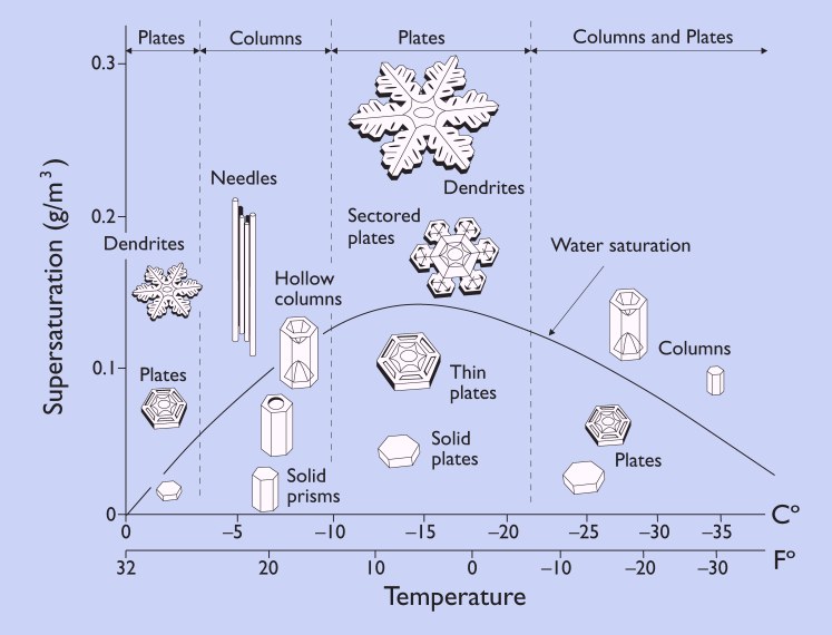
I should've been more prepared to shoot this sun pillar at a better location because they are rare in this part of the country, more rare than sun dogs and possibly rainbows. Sun pillars like to form from sunlight reflecting off the top and bottom faces of plate crystals that are tilted upward toward the sun, especially a few minutes after the sun has set. This
site explains the process very nicely. Given that supercooled altocumulus clouds were present, the pillar seemed to show a presence of a pretty widespread field of ice crystals which were probably dominated by plates. The roughly -10 to -15 C temperature of this layer can easily produce plates as long as the supersaturation is low. Take a look at the morphology diagram like this one from
snowcrystals.com.
I doubt the supersaturation was high otherwise we'd be looking at stronger updrafts and more beefy looking altocumulus castellanous, or a continuous sheet of nimbostratus if there was widespread lift. Then forget about seeing the sunlight. No, these little altocumulus were barely able to condense liquid water. They also formed quickly, as expected, before the pictures above were taken and then moved northeast overhead (see the satellite image below). Why was that expected? Because the rapid ice crystal formation would quickly scavenge the clouds of their water supply eventually converting all the altocumulus to ice trails (virga).
The satellite image also shows that this field appears to have been connected to the larger shield of warm advection clouds forming above a polar airmass from a departing surface high to the east. The 850 mb and 700 mb plots below show the gulf moisture sliding over the lower level cold air and perhaps our altocumulus cloud deck formed from this same warm air advection but in a very thin layer.
While the warm air advection happens relatively frequently (except when we're in drought) it is rare to get such a thin layer of lift to condense a small amount of moisture into altocumulus clouds at temperatures that support plates (for the best pillars) and yet have not had time for the liquid water to completely be scavenged out by the forming ice crystals. How many times a year do I see these conditions get met at sunrise or sunset without intervening cloud layers to dim the sun? Not too often. Next time I'll be prepared for a sun pillar shot but I suspect I'll see a lot of tornadoes before then.
 |
| Visible satellite loop from 2013-02-12 2002 to 2315 UTC. |
 |
| Surface analysis from NCEP/HPC for 2013-02-12 00 UTC. |


No comments:
Post a Comment