There's nothing more to add from tonight's guidance that wasn't considered in last night's. The uncertainty remains about the northern edge of the big snows as the SREF suite still insists NYC to Boston will get a major dump while the GFS keeps its southern solution.
 |
| The NAM forecast of total snowfall for a 10 to 1 snow ratio from this evening emulates the narrative the earlier SREF depicts of heavy snow fall well into New England. New York City to Boston would join in on the fun. Courtesy Pivotal Weather |
 |
| Meanwhile the GFS denies an epic snow fall for New York City to Boston. There is no scenario that denies the DC area an epic snowstorm. Courtesy of Pivotal Weather |
The big snow fall rates of 2-4"/hr will happen tomorrow pm in southwest VA, then spread into the DC to Shenandoah Friday night, finally into southeast PA and adjacent NJ Saturday afternoon. I favor this because it follows the motion of the 700mb WAA pattern, and perhaps the trough of warm air aloft as the upper-level low expands in size. However there's evidence that the DC area could be in the pivot region allowing more persistent snow well into Saturday night while at the same time the main system shifts more to the east.
 |
| Composite reflectivity and precip type from the high resolution NAM valid 03Z Saturday morning. The heaviest snow rates will be at the latitude of the DC area. |
 |
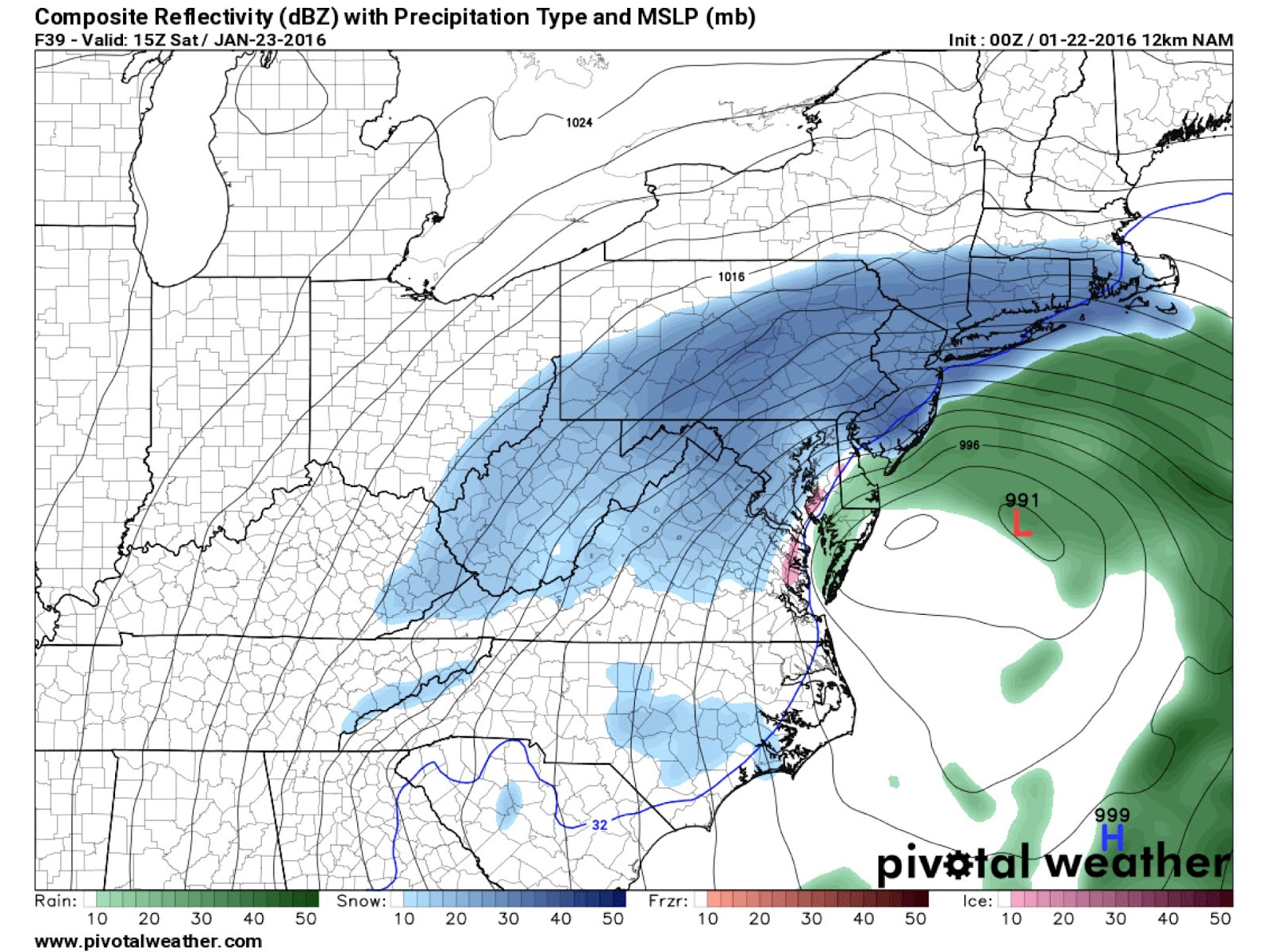
| By 15 Z Saturday the heavy band is forecast to shift north into Southern New England to southeast Pennsylvania. Snowfall remains in the DC area courtesy of the wrapping elevated and saturated warm air advection. |
The snow fall rates alone will be sufficient to overwhelm all but the most frequently plowed highways. Considering the advertised monster snow on a Friday night, I'm anticipating most roads to be clear of traffic allowing whatever plowing planned to be unhindered. If you are daring to go out, you may be in light company.
I anticipate this snow to be equivalent to what's experienced in a heavy lake Ontario long axis snow band. I've experienced this and the following is a quick synopsis of what you would experience. Basically I will assume you have enough ground clearance to handle up to a foot of snow on the highway though any more than that and you may need a hummer. Expect the <1/4 to 1/16 mile visibility in large dendrites clusters to rimed snowballs to slow you down to the point that snow will quickly clog up your wind shield wipers. You will need to stop frequently to give them a whack before starting up again. Clicking on the high beams will give you the feeling of the Millennium Falcon engaging hyperdrive. No doubt the sensation will be distracting to say the least.
I'm expecting at some point the excessive mess-alpha scale vertical motion field will sufficient vertical instability to generate lightning, momentarily blinding you in a sheet of brilliant orchid purple. No doubt you'll expect to hear a blast of thunder but with the insulating effect of billions of frozen hydrometeors the sound will be surprisingly muffled. If there is to be lightning, the snow may wind up falling as soft graupel the size of nickels to quarters. Such intense convective frozen precipitation has been documented by
Picca et al. (2014) in another epic snowband in Long Island. With temperatures approaching the melting point aloft, some of the grapple may appear refrozen, however the convective nature of the heaviest part of the band will prevent pure sleet. You'd have to be outside the band to see sleet, especially southeast of the district. One thing that may happen is that the band will be sufficiently electrified to charge the snow flakes and soft graupel to the point that it will stick to everything. It's quite likely signs will become caked with snow. Perhaps your car may as well requiring even more frequent wiping with your glove on the highway shoulder, should you find it. With the bad visibility and snow-caked highway signs, you'd better have a GPS enabled map to make sure you don't miss the exit should you wish to bail. If you do bail, make sure you've got 4-wheel drive or chains. There are plenty of hills that will offer up a free uncontrolled ride into something you don't want to hit.
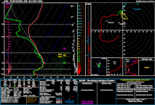 |
| Forecast sounding for Dulles International Airport from the 00 Z 4km NAM (1/22) valid for 09 Z 1/23. Note layers of conditional instability in the midlevels sufficient for generating lightning perhaps. |
One parameter I don't expect will be a serious problem for your Friday night journey will be gobs of blowing snow in the immediate DC area. The winds will be probably 10-20 mph in tree-covered residential areas, enough for blowing snow to temporarily blind you. However you should still be able to drive 15 mph or so without needing a spotter ahead of you to let you know where the edge of the highway happens to be. In serious lake effect bands the winds can be over 40 mph and that's when I've needed a spotter. By Saturday morning sunrise, the real pressure gradient will kick in and that's when you'll see the mass aerial migration of accumulated snow on trees, rooftops, and clearings. Serious whiteouts, of the lake effect kind, will commence and your journey will be accompanied by frequent intermissions while you attempt to figure out where the road went.
 |
| Ten meter wind forecast from the 00Z 4km NAM valid for 03 Z Saturday morning. The winds in the DC residential and urban areas will be < 20 mph for the most part. |
 |
Ten meter wind forecast from the 00Z 4km NAM valid for 15 Z Saturday morning. The winds in the DC residential and urban areas will be > 20 mph for the most part.
|
At this point, you don't want to just drive around a relatively tame, marginal blizzard. You want to see true gale force winds resulting in blinding amounts of blowing snow. For that, you'll need to head closer to the coast. The problem is that most coastal areas will likely experience ice pellets and thus all you'd experience is the sound of high-velocity peppering of BB's against your windshield. Instead, you may want to head to coastal NJ, preferably the northern half, south of Barnegat Light, to perhaps Avalon. This may be the sweet spot where the easterly low-level jet will smack unimpeded into the coast and then some distance inland while intersecting the cold enough temperatures and intense vertical velocity. This is the area that I'd expect true blizzard conditions. However, some of that action may get down to the northern Deleware and Chesapeake bays too. That's good because if you're meandering around the DC area in the snow, you will not make NJ for a loooong time.
 |
| probability of blizzard from the WPC winter storm impact graphics. Notice that coastal NJ, northern Deleware are really the only places to be hit. Coastal New England and Long Island may get blizzard but the SREF may be wrong about the northern extent of the snow. |
This is probably a good thing anyway because you may wind up being a little too adventurous and decide to drive into the path of boardwalk-breaching waves or perhaps a falling power pole. The surge will be impressive anywhere along the Deleware to New Jersey coasts. With the full moon, the morning high tide will send water up to 4 ft above normal water level at that time which will offer the remnants of the 20' waves offshore to nail you.
 |
| Waterlevel forecasts (normal tide in solid, forecast water level in dashed and confidence interval shaded) for Barnegat Light, NJ courtesy of SUNY Stonybrook. |