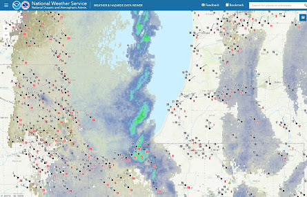
When I saw the flurry of social media posts showing radar data of an unusually coherent string of mesovortices, it brought back all sorts of memories to the day when Robert Sykes (the founder of SUNY Oswego's meteorology degree program) showed me examples of a temporal sequence of deep pressure drops in his lake effect field projects back in the late 1960's and 70's. Now come to this morning and the meteorological social media lights up with posts exclaiming about the amazingly coherent structure of the string of vortices traveling down the center of Lake Michigan, landing along Indiana/Michigan shoreline.
See these posts (1, 2, 3, 4, 5, 6, 7, 8, the last one is a plea to understand what is causing these vortices)
The impacts were typical of a lake effect band, low visibilities and snow covered roads (brief whiteouts along I-94, and here).
This is another example of the spectrum of vortices found in the cool season Great Lakes arena. I wrote about a much larger versions of these vortices, caused or enhanced by, converging land breezes, and/or by a localized mesocyclogenesis courtesy of a locally warmed airmass from convection and sensible heating by the lakes. With that background of vorticity, other, smaller scale vortices formed, even including water spouts.
But this event isn't that. This is a sequence of vortices lined up at regular intervals along a convergence zone. The winds reported around the south end of Lake Michigan show the converging flow right up to either side of the band. But the reflectivity structures depict more detail.
Two studies looked at the details of mesocyclone chains with diameters of a few km, like this one by Mulholland and co-authors 2017 and Steiger and co-authors in 2013. The 2017 paper's case study focused on mesovortices that were spaced about 6 km apart and had smaller diameters, perhaps around 2 km from eyeballing their figure 7. Many of these vortices had updrafts with them (though 1-3 m/s is not something that excites tornado chasers but it does excite lake effect nuts). They attributed the vortices to horizontal shearing instability, or HSI; this happens when there's an inflection point in the rate of the rate of change in the band-parallel wind across the band. I don't have a calculation of that wind but the process seems comparable between the 2017 case and here. The 2013 paper described a variety of vortex behaviors and initially brought up HSI. The background vorticity field develops from the same mechanism that accompanies the inflection point in the band-parallel winds. Winds are stronger on the right side of the band (right side when facing downwind) courtesy of the thermal low that forms over the lake. Shear vorticity forms in the background up to a point when HSI is favorable for the formation of a chain of equally spaced circular vortices. What triggers the roll-up of vortices is something I'm not sure is adequately answered but I think it becomes more likely if the convergence/vorticity increases or perhaps the background flow decreases (I know that sounds counterintuitive).
Even more of a question is how HSI can influence creating vortices that expand in size to to these diameters of 10-15 km and the accompanying braided reflectivity structure. The vortex diameter issue hasn't been explained yet but the braided structure has been documented along dry lines courtesy of Marquis and co-authors in 2007. I relate to their explanation that if the vortex is large compared to the width of the convergence boundary, then watch out for the vortices to distort the convergence boundary so that they create a "staircase shape along the span of the boundary". See their figure 14 here. I believe a regularly spaced pattern of weakened (enhanced) convergence forms fore and aft of (left and right) of each vortex as the vortex flow superimposes on the general general convergence. Clouds and reflectivity diminish as the vortex flow accelerates away from the background flow in the fore and aft positions.
So how rare is this feature? Well, there's a report on an earlier event back in 2004 by Grim and co-authors. This isn't new but certainly it's rare enough that every time it happens we notice them.
What wasn't around in 2004 was the HRRR or other CAMS models. How did they do? I'll just show the HRRR. Amazingly the background analysis of the HRRR captured what was needed for the model to generate similar vortex behavior though maybe not to the degree you'd want. Check out the 3 hour forecast from this morning. There's the braided reflectivity pattern with the string of vortices to accompany them.


No comments:
Post a Comment