Many areas have likely gotten rainfall that they haven't seen in decades including the Washington DC area. What is really amazing is that a few sites saw three to six hour rainfalls that exceeding even a 1000 year return interval. Even by tropical cyclone standards this is a pretty incredible total.
One case in point is the rainfall observed at Ft. Belvoir, VA. This site was nearly in the middle of a huge rainfall maximum of 9 - 12" that mostly accumulated on September 8, or the second day of heavy rain in the area (figure 1). A majority of this rain fell during the afternoon of the 8th as thunderstorms erupted in a north to south axis right across the western half of the Washington DC metro area.
 |
| Figure 1. 12 hour gauge bias-corrected radar-estimated rainfall centered over Washington DC and ending at 09 September 2011 01 UTC. The arrow points to Ft. Belvoir (KDAA). This data is available at http://www.srh.noaa.gov/ridge2/RFC_Precip/. |
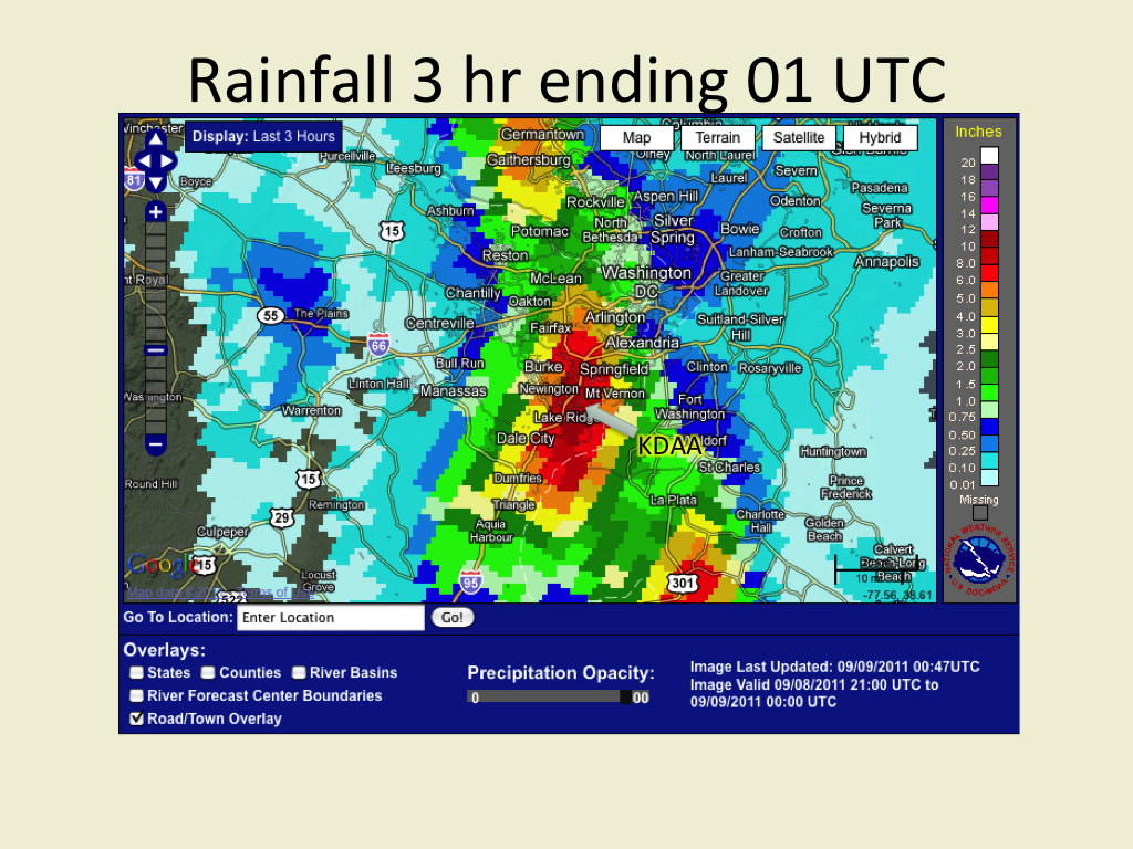 |
| Figure 2. Similar to figure 1 except for three hour rainfall ending at 01 UTC. |
Consider the rainfall accumulation at Ft. Belvoir (KDAA) as it compares to the expected time interval in which these kinds of rains are expected to occur. This is near the epicenter of the heaviest rainfall (figure 3). The measured hourly rainfall was quite heavy, peaking at 2.65" ending at 22 UTC but this kind of rainfall can be expected to occur once every 20 - 25 years. It's rare but nowhere near as rare as seeing this kind of rainfall rate persist past one hour to three hours! But that's what happened at Ft. Belvoir. They saw greater than 2"/hour rainfall rates last three hours yielding over seven inches! That's where we see that rainfall entering into the 1000 year return interval. Finally the thunderstorms let up and the rainfall rates diminished. Notice that the 12 hour rainfall of 7.9" is around a once in 200 - 300 year event and the 24 hour total of 9.3" is expected to occur once in perhaps 150 years.
 |
| Figure 3. A plot of rainfall vs period of rainfall accumulation for Ft. Belvoir, VA (black trace). In addition, this plot shows the maximum expected rainfall as a function of time for several return periods ranging from one year to 1000 years. Notice that the three hour rainfall at Ft. Belvoir exceeded the 1000 year return period! Rain return intervals acquired from NWS Hydrological Design Studies Center. |
So can you imagine what happens in a once in a thousand year rainfall event? Perhaps these pictures compiled from the Capital Weather Gang may provide some justice to the impacts. Needless to say the impacts were big in a negative way with multiple high water rescues, washed out roads, flooded buildings, and transportation halted in general. Numerous school districts were closed the following days. Residents in some areas were isolated due to damaged roads. And there were four fatalities.
So in summary, it's not just the rainfall amounts but also the rarity of these events that's important. Even though a thousand year rainfall event is basically a statistically-based extrapolation, the point is made that we should expect major societal impacts when the event is rare. The three hour rain that fell in Ft. Belvoir would even match a 100 year event along the upper Gulf Coast of the US according to the Rainfall Frequency Atlas.
That's all for now, however I'm going to look at what it takes to get a three hour rainfall of that magnitude from a meteorological point of view.
No comments:
Post a Comment