The summer of 2011 was bad for Oklahoma but the summer of 2012 is rapidly catching up. In fact the fires of August 3 were more intense than anything I've seen in 2011. Yesterday a fire blew up on the east side of Slaughterville, OK around noon and quickly grew as it spread north along 120th SE. Ave. When I came out to see the fire, it sported one large pyrocumulus on top of a plume-like updraft reminiscent of the east Noble fire in 2011 September 03. The only difference is that this fire looked much more likely to be a candidate for a firestorm considering the much stronger plume-like updraft.
A picture of the east Norman wildfire on 2012 August 03 1620 CST (2220 UTC). The fire plume is about 13 mi east of my location at the National Weather Center.
With a plume like that, it's no surprise that it showed up on radar. For much of the day the fire appeared as an oval of 25-40 dBZ echoes much like viewed below. On satellite the plume exploded in the late afternoon as it spread mostly east. Curiously there was a small appendage that formed and peeled off to the southeast.
On the left, a base reflectivity image from the Twin Lakes radar at 2228 UTC showing the reflectivity echo associated with the smoke and ash plume of the east Norman fire. On the right is the closest GOES visible satellite image of the fire within the circle. Other fires were burning near Chickasha tot he west and up by Mannford, OK in northeastern OK.
That small appendage to the southeast shows up very well in the time lapse I made of the event from 2146 - 2310 UTC. About 10 seconds into the video, the fire must've fed off some especially rich fuel sources that pumped a much stronger updraft into the air and raised the equilibrium level that much higher. Check it out below.
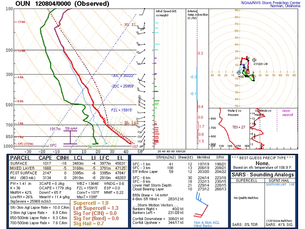
At the end of the video you may have seen a balloon launch from the small shack in the lower right part of the time lapse. This launch shows up in the sounding SKEWT chart below. The first thing of interest about the sounding is the exceptionally deep layer of steep lapse rates rising up to at least 5 km. Surface temperatures were exceptionally hot at near 110 deg F. Looking at the winds helps explain that southeastward pulse in the cloud when the strong updraft pulses took off and then encountered a layer of northwesterly winds at the 500 mb level. So this pyrocumulus cloud appeared to be quite high. In fact, I used the Theodolite app in my phone to measure the height of the cloud. I estimated that the plume was about 13 mi to my east which is how far 120 th to 132nd Ave is to the east. I got a cloud top height of 5.4 mi or around 8.6 km above the ground. With that information I could overlay the first picture in this blog on top of the sounding from the National Weather Center and it shows clearly that the cloud reached well into the northwesterly winds in the sounding. Also at that elevation the cloud should've been nearly -20 deg C! Wait, that's cold enough for significant glaciation. Yet the time lapse didn't show the top turning to ice. But it was close I'm sure. A couple hours later, I heard that Tim Vasquez, just south of Lake Thunderbird and northeast of the fire, reported rain! I heard other reports of rain too in that area. So this pyrocumulus was quite close to turning into a pyrocumulonimbus!
A SKEWT plot of the Norman, OK sounding from 2012 August 04, 00 UTC. The balloon was actually launched around 2304 UTC.
The Norman sounding from above was overlaid on the picture I shot at about time the fire produced the maximum cloud top height around 2220 UTC. I matched the height of 8.6 km to roughly the same position in the sounding.
At the end of the time lapse the plume weakened somewhat as the fire began to feel the effects of a cooling boundary layer. I drove eastward to my house (uncomfortably close to the fire) and by then the fire was producing mostly a wind-driven plume with a much lower maximum height. It was still producing pyrocumulus then but not nearly with the vertical extent as before. By night, the fire was purely a wind-driven plume as the nocturnal picture below shows. By the way at nightfall I was smelling smoke even though the main plume was to the east.
A picture of the east Norman fire from Post Oak and east of 108th Ave. SE around 2320 UTC.
A picture of the east Norman fire plume seen just above the trees taken from the west side of Lake Thunderbird at 2056 UTC or 2012 August 04, 0256 UTC. The eerie orange glow was fortunately located far enough southeast of us but still we were suggested to evacuate shortly thereafter.
The fire behavior that I've seen on this day has exceeded anything I've experienced in central Oklahoma. I've seen pyrocumulus the previous year but nothing compared to this. Certainly I've not heard of a fire producing a rain shower such as this one did. Perhaps I shouldn't be too surprised that we're passing into new territory. The temperatures over the past week have also exceeded anything I remember before. In the previous two days the temperatures have reached above 110 deg F. The Norman mesonet site has breached 113 deg F. That's tying the all-time record max temperature at the Oklahoma City airport. Then on this day the airport itself tied its all-time high temperature record. What's more, this day was the hottest day ever because the morning maximum low temperatures were hotter than ever before. Some areas couldn't get below the upper 80's F!
Maximum temperatures from the Oklahoma mesonet sites on 2012 August 02.
A surface plot on 2012 August 12 at 22 UTC with the area in orange exceeding 110 deg F.
Maximum temperature record tied at Oklahoma City on 2012 August 03.
With these unprecedented temperatures, the burn index was higher than I've seen last year. The 10 hour dead fuel moisture was exceptionally low. Any other fire index that has been made also showed unusually favorable values around here.
Two fire parameters produced by the Oklahoma Climate Survey, the burning index above and the 10 hour dead fuel moisture below for 23 UTC 2012 August 03.
Another aspect of these fires that I've never seen before is that we've now finished the second day of this fire with little hope that it'll be contained before sunrise. Seeing two days of active fire is unusual to say the least. Unfortunately that means the fire has consumed a large amount of terrain and many residents have become victims to its persistence. I know of several friends that still don't know the fate of their houses. Now the fire has entered into the Clear Bay area of Lake Thunderbird and also is spreading toward Little Axe.
A real-time fire map made available based on reports received from the Cleveland County fire authorities.
And finally, this fire is nowhere near the size of the one east of Mannsford, OK. That fire has exploded today with a 10 mi long front and a plume that has actually created cumulonimbi, and quite likely thunderstorms, as the atmosphere has destabilized ahead of a cold front. This fire has possibly reached 40,000 acres in size.
The composite reflectivity image from the KINX radar at 2012 August 04 2152 UTC showing nearly 50 dBZ echoes downstream of the Mannford, OK fire. The corresponding GOES visible image showed cumulonimbi embedded within the fire plume. Other high-based cumulonimbi started to initiate along the front to the north.


No comments:
Post a Comment